Water on Gabo Island: Springs, Tanks and Rainfall
How an isolated granite island in the Tasman Sea captured, held, and relied upon fresh water — from natural dune-fed springs and historic lightkeeper cisterns to modern reverse osmosis.
Natural Springs and the 1860s "Ever-Flowing" Stream
During the early colonial era of the lightstation, Gabo Island possessed natural, reliable surface freshwater springs that sustained the first resident families and workforce (Love of Mallacoota, pp. 102–103) [1]. In a childhood memoir recording life on the island between 1862 and 1865, a keeper's child recalled:
“Gabo had two springs, one coming from a lakelet behind the hills and draining beneath them; the smaller one to which we went for drinking water when the spray had made the tank water brackish.”
— Love of Mallacoota (2nd edn, 1998, p. 103), reprinting Gap magazine (1965) [1]
Prior to the completion of the 1862 permanent granite lighthouse on the southern cliffs, the original keepers’ quarters were situated close to the northern landing at Santa Barbara Bay. The memoir records the immediate availability of fresh running water beside the harbour (Love of Mallacoota, p. 103) [1]:
“…their quarters on the shores of the little bay with its stream of ever-flowing water…”
— Love of Mallacoota (p. 103) [1]
“…my mother's exclamation of pleasure caused by the sight of the beautiful stream of water falling into the sea.”
— Love of Mallacoota (p. 103) [1]
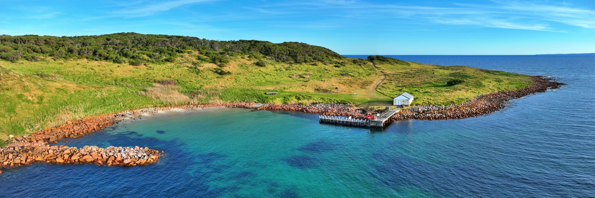
Gabo Harbour & Jetty
GEN-PANO-016The island landing. A granite breakwater, a white shed on the jetty and clear water in Santa Barbara Bay.
The station also relied on corrugated iron water tanks. In heavy sea fog, these tanks were struck rhythmically as an improvised station fog alarm (Love of Mallacoota, p. 103) [1]. To sustain their diet in isolation, the family dug “deep drains” and successfully cultivated domestic vegetables (Love of Mallacoota, p. 103) [1].
Keepers’ Cisterns & The Salty First Rain (c. 1900)
With the lightstation permanently established on the exposed southern headland, roof catchment into storage tanks became central to daily survival (Love of Mallacoota, p. 105) [1]. Because fierce ocean gales frequently blanketed the roofs in dense maritime salt spray, lightkeepers developed strict first-flush procedures.
Extracts from the diary of head keeper John Macdonald’s daughter (Macdonald was head keeper on Gabo Island from 1900 to 1915, recorded in Love of Mallacoota, p. 105) explain how families managed their drinking water:
“if you didn't turn the water off the tanks when it started to rain, the water was a bit salty, but once was enough...”
— Eileen McKee’s mother’s diary, Love of Mallacoota (p. 105) [1]
Despite the harsh oceanic environment, keeper families established sheltered garden plots in low depressions to take advantage of moist soil:
“we were all happy in a valley on the island where Mum used to grow vegies”
— Eileen McKee’s mother’s diary, Love of Mallacoota (p. 105) [1]
Happy Valley, Springs & The Earth Dam
Archival surveys and heritage registrations held in the Victorian Heritage Database (VHR H1843 / Places 2022 and 125258), based on the 1992 Conservation Management Plan prepared by Nelsen, Miller & Sawyer, record physical evidence of water collection across the island’s interior (VHD H1843) [2]:
“There have been several other sites for gardens most notably ‘Happy Valley’. This valley is watered by a spring and has some remnants of fencing and tanks. There are several mature fruit trees.”
Works staff on large infrastructure projects “were housed in sheds near the earth dam.”
— Gabo Island Lightstation Conservation Management Plan (1992), cited in Victorian Heritage Database VHR H1843 [2]
A keeper who arrived on Gabo Island in 1879 similarly recalled the presence of “vegetable gardens and springs” (VHD H1843) [2]. Heritage documentation notes the fundamental geological structure of the island: Gabo Island is formed of red porphyritic granite overlaid by sand dunes, with a ridge of sand dunes reaching up to 50 metres in the centre of the island (VHD H1843) [2].
Livestock on the Island & Water Supply
Lightkeepers introduced cattle to Gabo Island in the 19th century to provide fresh milk and beef for the isolated community (ABC News, 3 May 2019) [4]. When Parks Victoria assumed management of the island in 1996, the herd had already been grazing the island’s sandy pastures for many decades.
In May 2019, an ABC News investigation documented that a herd of 13 cattle was grazing on the island (ABC News) [4]. Parks Victoria stated at the time that it was maintaining the herd until the full ecological impact of removing the cattle on native seabird colonies was understood, as the cattle helped suppress invasive kikuyu grass and trampled tracks utilized by nesting Little Penguins (ABC News) [4].
No more recent public information was found regarding whether the herd remains on the island today.
Modern Cottage Water System
Today, visitor accommodation is provided in the heritage Assistant Lightkeepers Cottage, operated by Parks Victoria. In the statutory Parks Victoria Safe Drinking Water Annual Report 2008–2009 (p. 4, Table 1), the lightstation water system is officially documented as follows (Parks Victoria 2008–09) [3]:
“Water is captured on cottage roof and held in two above-ground poly tanks. Water to the guest cottage's kitchen is passed through a reverse osmosis (RO) unit. Water reticulated through the rest of the cottage is not treated.”
— Parks Victoria Safe Drinking Water Annual Report 2008–2009, Table 1 (Source: Rainwater; Treatment: Sedimentation and reverse osmosis) [3]
This description reflects the system as described in 2008–09. The exact current set-up following the cottage's 2024–25 reopening is not confirmed.
Visitor Notice: Gabo Island has no municipal mains water. Water conservation is strictly mandatory for all staying guests and staff. Visitors should follow Parks Victoria’s current advice on drinking water [3].
Rainfall & Climate Baseline (1859–2026)
Official weather observations have been recorded continuously at Gabo Island Lighthouse (Bureau of Meteorology Station 084016) since 1859 — representing a 165-year climate record (Bureau of Meteorology) [5]:
936.1 mm
Long-term mean annual rainfall (1859–2026)
101.4 days
Average annual days with rainfall ≥ 1.0 mm
Monthly Mean Rainfall (mm)
| Month | Mean (mm) | Days ≥ 1mm | Precipitation Relative Scale |
|---|---|---|---|
| January | 70.4 | 6.8 | |
| February | 67.2 | 6.1 | |
| March | 72.7 | 7.7 | |
| April | 84.1 | 9.3 | |
| May | 98.2 | 11.2 | |
| June | 102.3 | 10.9 | |
| July | 84.1 | 10.1 | |
| August | 71.4 | 9.6 | |
| September | 70.5 | 9.1 | |
| October | 74.0 | 9.1 | |
| November | 73.4 | 8.2 | |
| December | 68.1 | 6.9 | |
| Annual Total / Mean | 936.1 mm | 101.4 days | BOM Station 084016 (1859–2026) |
Sources & References
- Edna J. Brady (ed./publisher), Love of Mallacoota, 2nd edn, 1998, ISBN 0-646-34922-8.
pp. 102–103: “Memories of a Happy Childhood, 1862–1865 Gabo Island” (reprinted from Gap magazine, 1965; child at lightstation 1862–65); p. 105: Diary extracts of Eileen McKee’s mother (daughter of head keeper John Macdonald, 1900–1915). Archived copy: Love of Mallacoota (PDF). - Victorian Heritage Database (Heritage Victoria), Gabo Island Lightstation, Victorian Heritage Register VHR H1843 (VHD Place 2022) and Gabo Island Radar Station (VHD Place 125258), citing the 1992 Conservation Management Plan by Nelsen, Miller & Sawyer.
URL: vhd.heritagecouncil.vic.gov.au/places/2022. - Parks Victoria, Safe Drinking Water Annual Report 2008–2009, Table 1, p. 4 (“Water is captured on cottage roof and held in two above-ground poly tanks...”).
Current park advice: Parks Victoria Drinking Water Safety Tips. - ABC News, “Gabo Island Little Penguins blocked from burrows by kikuyu grass”, 3 May 2019.
Documenting Parks Victoria herd history and 13 cattle grazing on Gabo Island in 2019. URL: abc.net.au/news/2019-05-03/gabo-island-little-penguins-blocked-from-burrows-by-kikuyu-grass/11073470. - Bureau of Meteorology, Climate Statistics for Australian Locations — Gabo Island Lighthouse (Station 084016), continuous records from 1859 to 2026.
URL: bom.gov.au/climate/averages/tables/cw_084016.shtml.